Far Southwest: Magdalena Contreras on Foot
Why Magdalena Contreras
Santa María Magdalena Atlitic is where Mexico City runs out of city. It is an old village at the mouth of the valley of the Río Magdalena, the last river in the capital that still runs in the open. Above it are the forests of Los Dinamos. Below it, along the river, are the ruins of the textile mills the river once drove, a mill owner’s house, a workers’ church and a station on the old railway to Cuernavaca.
It is in the far south-west, in the borough of La Magdalena Contreras, between the Sierra de las Cruces and the Ajusco. The walk follows the water downhill: from a riverside park at the foot of the valley, through the village square and its church, along Avenida Álvaro Obregón past the borough hall and the old station, to the mill district of La Concepción.
This walk suits people who have done the center and want to see a pueblo that still has a fiesta, a market and a river, and who like industrial history. It is a long ride from Roma, the coffee scene is thin, the sidewalks on Álvaro Obregón are narrow, and the river is not as clean as it looks. It is also mostly downhill, which I count as a point in its favor.
Practical basics
The walk is about 3.3 km, one way and mostly downhill, and takes a long morning with stops. Take an Uber or taxi to the start and home from the end. Do it on a Saturday.
| Start | La Cañada, Calle Cañada s/n, La Carbonera, at the foot of the Los Dinamos valley |
| Finish | La Conchita, Camino Real de Contreras 7, La Concepción, next to the Foro Cultural |
| Distance | About 3.3 km; roughly 45 minutes of pure walking |
| Time needed | 3 hours with breakfast at the market and a look inside the Foro |
| Best day | Saturday: the market by the church is busiest, the church and the Casa de Bellas Artes are open and the pulque shop is open |
| Avoid | Wednesday, when the parish church is closed, and Sunday if you want the Casa de Bellas Artes |
| Toilets | The Mercado Turístico across from the church has toilets (they charge a few pesos); the Foro Cultural too |
There is no Metro, Metrobús or Tren Ligero nearby. RTP bus 126 runs from Metro Universidad and Metro Copilco to the Explanada de la Alcaldía (stop 4), and buses marked Dinamos run from Metro Viveros and Metro Taxqueña up to the valley.
If you want more forest, the road keeps climbing from La Cañada up the valley to the four Dinamos, the old power stations. The first is about an hour’s walk uphill. Local community groups charge small fees at each section (Google reviews mention 20 to 50 pesos, ~1–2.60 USD), most stalls take cash only, and there is little or no phone signal further in. Go early, with company, and arrange your ride back before you lose signal.
Walk in daylight. La Cañada is full of families on weekend mornings, but on holidays it also gets drinkers; eat, look at the river and move on. Keep your phone away around the bus stops on Álvaro Obregón, and walk facing the traffic where there is no sidewalk. The borough has stepped up police patrols in La Magdalena and Los Dinamos since January 2026.
A short history
People lived here long before the Aztecs. Settlements from about 500 to 200 BCE were under Cuicuilco, and when the Xitle volcano buried Cuicuilco its people moved higher up. Otomí groups followed, then Tepanec rule from Coyoacán, then the Aztecs, who called the place Atlitic. The name is usually given as “place of much water”, or “stone that drinks water”, after a rock that rose from a small lake. It is one of the borough’s four original villages, with San Bernabé Ocotepec, San Nicolás Totolapan and San Jerónimo Aculco.
Friars arrived in 1535 and made Mary Magdalene the patron saint, keeping the old name. A 16th-century hermitage became the present church, whose facade dates from 1760; it was declared a national monument in 1932. The river was put to work early. In 1543 Jerónimo de León built a water-powered mill, and in the 17th century the Contreras family set up the textile works that gave the borough its name.
By the late 19th century the river drove a string of textile mills, among them El Águila Mexicana, Santa Teresa, Loreto and La Magdalena, making wool, cotton and cashmere cloth. El Águila opened in 1849. In 1897 Ángel Sánchez and French investors built four hydroelectric plants up the valley to power them: the Dinamos. Cloth went out on the Mexico City to Cuernavaca railway, whose Train 501 also carried Diego Rivera and Tin Tan. The composer Juventino Rosas (1868–1894) is said to have written the waltz later called Sobre las olas to the sound of the La Magdalena mill.
In 1900 the area was still rural, with 8,150 people, most of them in La Magdalena. In 1928 the municipality was abolished and it became a borough of the city. The population passed 40,000 by 1960; the Periférico arrived in 1963. The La Magdalena mill closed in the 1970s, and on May 3, 1979 the ruins of El Águila reopened as the Foro Cultural. The railway was shut down in 1997 and the Contreras station became a park.
In 2011 Santa María Magdalena Atlitic became the first of the city’s Barrios Mágicos. In February 2025 the old Cine Víctor Manuel Mendoza reopened after more than 40 years closed, with free films, and had more than 20,000 visitors in its first year. The river is still the city’s only living one, though untreated wastewater still gets into it.
The route
The walk runs one way, downhill from the Río Magdalena at La Cañada through the village to the mill district of La Concepción, in 10 numbered stops. Follow it on the Magdalena Contreras on Foot map, which shows every stop, the walking route, the cafés and bakeries along the way and the nearest chain cafés.
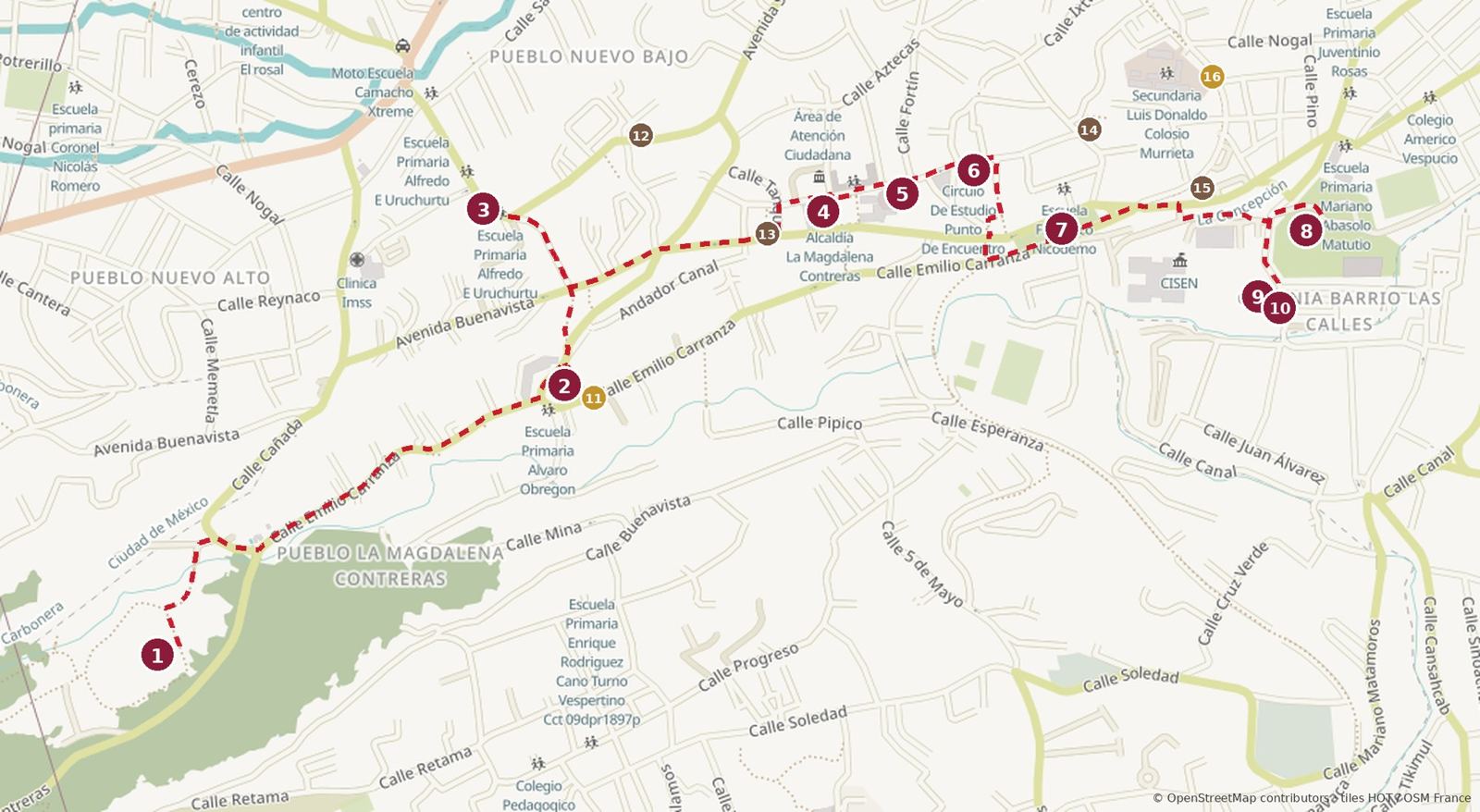
Coffee 12Café Jardín · 13Holistika Café · 14Milu Tuun Café · 15El Rincón de Paris
Bakeries 11Panadería Berna · 16Panadería y Pastelería Piña
Click to enlarge. Map data © OpenStreetMap contributors.
| # | Stop | What it is |
|---|---|---|
| 1 | La Cañada | Riverside park, Río Magdalena |
| 2 | Parroquia de Santa María Magdalena Atlitic | 18th-century village church |
| 3 | Los dioses del agua | Ariosto Otero mosaic mural |
| 4 | Explanada de la Alcaldía | Civic square and murals |
| 5 | Cine Víctor Manuel Mendoza | 1930s cinema, free films |
| 6 | Mercado La Loma | Neighborhood market |
| 7 | Parque del Ferrocarril | Old Cuernavaca railway station |
| 8 | Foro Cultural Magdalena Contreras | 1849 textile mill, culture center |
| 9 | Casa de Bellas Artes Juventino Rosas | Mill owner’s house, arts school |
| 10 | La Conchita | The mill workers’ church |
The walk, part 1: the river to the village
The first half is the old pueblo: the river, the church and breakfast in the market across the street.
1. La Cañada
Calle Cañada s/n, La Carbonera · open daily; daylight only · free (stalls charge)
Start where the valley opens out and the Río Magdalena comes down out of the forest. La Cañada is a natural park along the river: families with grills and hammocks, dogs, food stalls and very cold water. Look at it, put a hand in the river, and think about how far it has to go through the city. Don’t drink it. If you have the energy, the road up to the Dinamos starts here (see Practical basics).
Snack: the stalls here do trout, quesadillas and café de olla, if you need something before you set off.
2. Parroquia de Santa María Magdalena Atlitic

Emilio Carranza s/n · Mon–Tue and Thu–Fri 9:00–18:00, Sat 9:00–14:00, Sun 7:00–18:00, closed Wed; check · free
Walk about 12 minutes downhill on Emilio Carranza to the village square. The church began as a 16th-century Franciscan chapel and was rebuilt in the 18th century. The facade, dated 1760, is Baroque with Mudéjar touches in the brickwork. The atrium is cobbled and shaded, with a fountain topped by St. Michael. Inside is a neoclassical altar and a large painting of the Magdalene. On July 22 the plaza fills for her fiesta, with food, fireworks, music and rides.
Breakfast: the Mercado Turístico La Magdalena (Calle Magdalena 528) is across the street, Mon–Fri 8:00–19:00, Sat–Sun 8:00–20:00. It is where people eat before and after Los Dinamos, and the fondas serve seasonal mountain food: mushroom soup, giant quesadillas, birria de chivo, barbacoa, pancita. Antojitos Pily (local 33) is a reliable stall. Sit at the counter and order whatever has hongos in it. If you would rather take something with you, Panadería Berna is on Emilio Carranza by the church (gold circle on the map).
3. Los dioses del agua
Av. del Rosal, Pueblo Nuevo Bajo · exterior · free
Walk about five minutes north into Pueblo Nuevo Bajo. On the wall of the borough’s water office is a mural by Ariosto Otero, the muralist whose work you will keep running into in this borough. It is done in mosaic with copper inlays and it is angry about how the city treats its water, which is fair, given the river you just saw.
Coffee break, afternoons only: Café Jardín (Callejón de la Perita 15), a café with a garden and crepes, is about four minutes away, Mon–Sat 16:00–21:00 (brown circle on the map).
4. Explanada de la Alcaldía
Av. Álvaro Obregón 20, Barranca Seca · open space · free
Walk about nine minutes east to one of the smallest borough seats in the city. The Explanada is where local life happens: official events, concerts, dances, exhibitions. On weekdays it is full of students from the school next door. Ariosto Otero painted the two big murals in 2001: Identidad y esclavismo on the north side, and Gran Círculo de Obreros Libres above the stairs down to Álvaro Obregón. There is a large kiosk on the east side.
Coffee break: Holistika Café (Av. Álvaro Obregón 103), about two minutes from the Explanada, Mon–Fri 9:00–21:00, closed Sun (brown circle on the map).
The walk, part 2: the railway to the mills
The second half follows Álvaro Obregón down past the cinema, a market and the old station to the mills at La Concepción.
5. Cine Víctor Manuel Mendoza
Fortín 5, Barranca Seca · check program · free
Two minutes away is the cinema everyone calls El Piojito. It opened in the 1930s as the Cine Contreras; soon after, the actor Víctor Manuel Mendoza bought it and gave it his name. It closed and stayed shut for more than 40 years. The city expropriated it in 2012, the borough restored it, and it reopened on February 14, 2025. Films, workshops and even the popcorn are free. Check what is on and come back for a screening.
6. Mercado La Loma
Calle J. Moreno Salido 97, Barranca Seca · daily 8:00–18:00
Two minutes further is the market locals use, quieter and cheaper than the one by the church. Moles Rosita sells moles and dried chiles, there is fruit and veg in season, and there is a candy stall worth a look.
Coffee or lunch: Milu Tuun Café (Calle J. Moreno Salido 35) is a couple of minutes up the same street, closed Sun (brown circle on the map). If you skipped breakfast at the church, the market has food of its own.
7. Parque del Ferrocarril
Ferrocarril de Cuernavaca at Av. Álvaro Obregón · check hours · free
Walk about five minutes on to the site of the Contreras station on the old Mexico City to Cuernavaca line. Old rail cars and signals are still there, and the park is part of the cycle path that now runs along the old track bed. The main reason to come is Ariosto Otero’s Viaje del siglo XX, 42 meters long and 5 meters high, about the train’s long run through La Magdalena, made partly with sleepers, rails and signals from the original line. The little station museum is only sometimes open. No dogs.
Pulque, weekends only: Pulques El Vaivén (Av. Álvaro Obregón 1533) is about three minutes away, Sat 11:00–18:00, Sun 11:00–17:30. Coffee: El Rincón de Paris (Av. Álvaro Obregón 1445), daily 8:00–21:00, is about three minutes the other way (brown circle on the map).
8. Foro Cultural Magdalena Contreras

Camino Real de Contreras 27, La Concepción · daily 6:00–21:00, check · free
Walk about six minutes down to the lowest part of the walk and the El Águila mill, built in 1849 to make casimir, a fine wool cloth. According to the Foro’s own story, Diego de Contreras named it after his wife, Isabel del Águila. A fire brought the roof down, the company closed, and the government took over the site; since May 3, 1979 it has been a cultural center. The smokestack, an old dynamo, pipes from the water system and the original gate survive. There is an open-air ágora for about 300 people, an auditorium, libraries, a sculpture walk, five-a-side pitches and a lot of skateboarders.
9. Casa de Bellas Artes Juventino Rosas

Camino Real de Contreras, next to La Conchita · Mon–Fri 9:00–20:00, Sat 9:00–16:00
Three minutes away is the 17th-century “casa del patrón”, the boss’s house of the La Magdalena mill, owned for most of its life by the Contreras family. INAH lists it as a historic building; restoration turned up older floors and a staircase. It has been an arts school since 1979, known for dance, and you can walk into the garden. It is named after Juventino Rosas, and the story goes that the waltz came from the sound of the mill next door.
10. La Conchita

Camino Real de Contreras 7, La Concepción · check hours · free
End next door at the Templo de la Inmaculada Concepción, which everyone calls La Conchita. It began as the Contreras family’s private chapel and grew as the workforce did; the present church is 17th century. Diego de Contreras also built Las Calles, 114 houses for his workers, in the streets around it. Chilango says Juventino Rosas lived in the church offices for a time. Uber pickups are easy on Camino Real de Contreras.
Pan dulce for the ride home: Panadería y Pastelería Piña (Ferrocarril de Cuernavaca 26) is about five minutes north (gold circle on the map).
Coffee, food and drink
For breakfast, go to the Mercado Turístico; for coffee, Holistika Café; for a drink, El Vaivén on a weekend.
| Place | What | Where |
|---|---|---|
| La Cañada stalls | Trout, quesadillas, café de olla | Stop 1 |
| Mercado Turístico La Magdalena | Fondas: mushroom soup, quesadillas, birria | Calle Magdalena 528, across from stop 2 |
| Antojitos Pily | Market antojitos | Mercado Turístico, local 33, by stop 2 |
| Panadería Berna | Bakery | Emilio Carranza, by stop 2 |
| Café Jardín | Café with a garden, crepes; Mon–Sat 16:00–21:00 | Callejón de la Perita 15, near stop 3 |
| Holistika Café | Café; Mon–Fri 9:00–21:00, closed Sun | Av. Álvaro Obregón 103, near stop 4 |
| Mercado La Loma | Moles, chiles, market food | Stop 6 |
| Milu Tuun Café | Café; closed Sun | Calle J. Moreno Salido 35, near stop 6 |
| Pulques El Vaivén | Pulque; Sat 11:00–18:00, Sun 11:00–17:30 | Av. Álvaro Obregón 1533, by stop 7 |
| El Rincón de Paris | Café; daily 8:00–21:00 | Av. Álvaro Obregón 1445, near stop 7 |
| Panadería y Pastelería Piña | Bakery | Ferrocarril de Cuernavaca 26, near stop 8 |
If you just want a familiar cup, there is nothing on the route; the chains are a short ride east:
- Lecaroz bakery at Av. México 1179, Santa Teresa
- Starbucks at Av. San Jerónimo 819 (Pasaje San Jerónimo) and on Blvd. Adolfo López Mateos in San Jerónimo Lídice
Shops worth the detour
Shopping here is food.
- Mercado La Loma (stop 6): Moles Rosita for mole paste and dried chiles to take home.
- Mercado Turístico (across from stop 2): fresh produce and whatever the mountain is giving that season, mushrooms in the rainy months.
- Panadería Berna (by stop 2): pan dulce from the village square.
- Foro Cultural (stop 8): the crafts workshops sometimes sell work, alebrijes among it; check what is on.
Which day to walk
Saturday gets you the most. Only the stops and places with limited days are listed below.
| Stop | Mon | Tue–Fri | Sat | Sun |
|---|---|---|---|---|
| 2 Parroquia de la Magdalena | Open | Closed Wed | Until 14:00 | Open from 7:00 |
| 4 Borough offices | Open | Open | Until 14:00 | Closed |
| 9 Casa de Bellas Artes | Open | Open | Until 16:00 | Closed |
| Pulques El Vaivén | Closed | Closed | Open | Open |
| Holistika Café | Open | Open | Open | Closed |
On a Sunday, go early: the church opens at 7:00, the market across from it is at its busiest, and you can end with pulque at El Vaivén.
Keep walking
Up: Los Dinamos. From La Cañada the road climbs the valley past the four old power stations. Rancho La Rosita at the second Dinamo lets you catch your own trout and cooks it for you. Allow a full day and plan your ride back.
East: San Jerónimo Lídice. A short taxi from the finish, with cobbled streets, a 16th-century Franciscan church with an open chapel, the Plaza Lídice and its Rose Garden of Peace and another Ariosto Otero mural. Bencomo there is the borough’s best-known restaurant.
South: San Nicolás Totolapan. About 20 minutes from the Explanada, another original village, with a church founded in 1535 and the ejido’s ecotourism park.
About the author and where to stay
Brian has lived in Roma Norte for about five years and writes the See Mexico City guides. He speaks seven languages and still gets lost on purpose.
When you visit, stay with us at Penthouse El Cielo de Roma in Roma Norte.
Photo credits
Photos via Wikimedia Commons, used under the licenses shown. Numbers match the captions.
- La Iglesia de La Magdalena en la colonia La Magdalena en la entrada a Los Dinamos.jpg, Noemibrickman, CC BY-SA 4.0
- ForoCulturalMC03.JPG, AlejandroLinaresGarcia, CC BY-SA 3.0
- IglesiaConcepcionContreras15.JPG, AlejandroLinaresGarcia, CC BY-SA 3.0
- IglesiaConcepcionContreras10.JPG, AlejandroLinaresGarcia, CC BY-SA 3.0
Map: drawn from OpenStreetMap data, © OpenStreetMap contributors, Open Database License.
Sources
Hours and prices checked October 2026; confirm before you go.
- Wikipedia: Magdalena Contreras
- Mexico City tourism: Magdalena Atlitic church, Magdalena Atlitic, La Magdalena Contreras, La Conchita and Casa de Bellas Artes, Ferrocarril Park, La Magdalena Contreras Esplanade, Mercado Turístico La Magdalena, Magdalena Contreras, El banquete rústico del río vivo
- Chilango: Foro Cultural en Magdalena Contreras, El Piojito, el cine gratis, Barrios mágicos en el DF, Guía para visitar Los Dinamos
- Time Out México: Foro Cultural Magdalena Contreras, Parque de los Dinamos, Murales de Ariosto Otero
- N+: Lista completa de los Barrios Mágicos de la CDMX
- Excélsior: Magdalena Contreras refuerza patrullajes nocturnos en Los Dinamos