East: Iztacalco on Foot
Why Iztacalco
Iztacalco was an island in Lake Texcoco, settled by the Mexica before they founded Tenochtitlan. The lake is gone, the canal is a road, and the borough around it is the most densely populated in the city. In the middle of all that concrete the old pueblo is still there: a Franciscan church and convent on a village plaza, and seven barrios, each with its own chapel, saint and fiesta.
It sits south-east of the Centro, below the Viaducto Río de la Piedad and along the Calzada de la Viga, which follows the line of the old Canal de la Viga. The walk crosses the pueblo from the Barrio de Santiago, west of the old canal, through the plaza and the eastern barrios to Santa Anita Zacatlamanco on the Viaducto edge. The ground is flat, the streets are narrow and the distances are short.
This walk suits people who want to see how a lake village turned into a city neighborhood without quite letting go. It is not a tourist district. Several chapels open only for Mass, the plaza can be scruffy, and the Calzada de la Viga is a wide, fast road you will cross twice. Nobody will try to sell you anything except quesadillas. I like that about it.
Practical basics
The walk is about 4.4 km, one way, and takes half a day with stops. Take an Uber or taxi to the start and home from the end. Do it on a Thursday or Friday, when the most chapels, the café and the pulquería are open.
| Start | Santiago Apóstol, Av. Santiago 54, Santiago Norte |
| Finish | Santa Anita Zacatlamanco, Av. Hidalgo, near the Viaducto |
| Distance | About 4.4 km; roughly 1 hour of pure walking |
| Time needed | 3–4 hours with coffee and lunch |
| Best day | Thursday or Friday: San Miguel, Santiago, Santa Anita, the café and the pulquería are all open |
| Avoid | Tuesday (pulquería closed) and Wednesday (Santa Anita and San Francisco closed); Monday closes San Miguel and Santiago |
| Toilets | The Mercado Iztacalco has public toilets; or buy something at Eoz Café or the pulquería |
If you come by public transport, there is no Metro near the start; Metro Coyuya (Line 8) is about five minutes east of Los Reyes (stop 9), so you can join the walk there. Metro Santa Anita (Lines 4 and 8) is about five minutes north-east of the finish. Metrobús Line 2 stops at La Viga, on Eje 4 Sur at the Calzada de la Viga, between stops 11 and 12.
Start around 10:00 on a weekday. You reach San Matías just after it opens, San Francisco Xicaltongo before it closes at 13:00, lunch around 13:00 and Santa Anita in the afternoon. If you are short of time, do only stops 1 to 8, from Santiago to San Miguel; that is about 1.5 km.
The pueblo is a residential area and feels calm by day, but it is not polished. Walk it in daylight. Cross the Calzada de la Viga only at the lights. Reviewers say the plaza around the kiosk sometimes collects litter and people drinking or using drugs; it is busy and fine at midday. In San Francisco Xicaltongo some lanes are private walkways; stay on the streets. Keep your phone away around Metro Santa Anita at the end.
A short history
Tradition says the Mexica settled the island of Iztacalco in 1309, sixteen years before they founded Tenochtitlan. The name is usually read as “in the house of salt”, and people here made salt from the lake’s brackish water into the early 20th century. After the Triple Alliance formed, the island came under Texcoco.
After the conquest the Franciscans built a small convent dedicated to San Matías; one popular date is 1564. The village was divided into barrios, each with a saint’s name and a Nahuatl one: La Asunción Atenco, Los Reyes Izcuitlán, Santiago Atoyac, San Miguel Amac, Santa Cruz Atencopa, San Sebastián Zapotla and San Francisco Xicaltongo. A chapel to Saint Anne at Santa Anita appears in records from 1554. In 1725 the architect José Miguel de Rivera Saravia renovated San Matías.
As the lake was drained, the islanders built chinampas on the new land and grew flowers and vegetables. The Canal de la Viga carried them to the city in canoes and trajineras, along with goods from Chalco and Xochimilco. A steamboat ran to Chalco from 1850. On weekends city people came out by boat, and the Viernes de Dolores flower festival at Santa Anita was one of the great fiestas of the 19th century. Diego Rivera painted it in the SEP murals.
Iztacalco became a municipality in 1862 and a borough of the city in 1928. The canal was closed to boats around 1915 for health reasons and later paved as the Calzada de la Viga; the city tourism site dates the final paving to 1957. From the 1950s the fields were divided into lots for factory workers, and in less than four decades the area went from rural to fully urban. The Río de la Piedad, the northern edge, was piped and covered by the Viaducto.
In 2011 the city made the old center of Iztacalco a Barrio Mágico. The Casa de Cultura Siete Barrios, a Porfirian jail turned borough office, was restored in 2003–2006, and in September 2024 INAH showed 38 old photographs of the canal there, taken between 1880 and 1950.
The route
The walk runs one way, from Santiago on the west side of the Calzada de la Viga across to the plaza of San Matías, east through the barrios to Los Reyes, then back over La Viga and north to Santa Anita on the Viaducto edge, in 13 numbered stops. Follow it on the Iztacalco on Foot map, which shows every stop, the walking route, the cafés along the way and the nearest chain cafés.
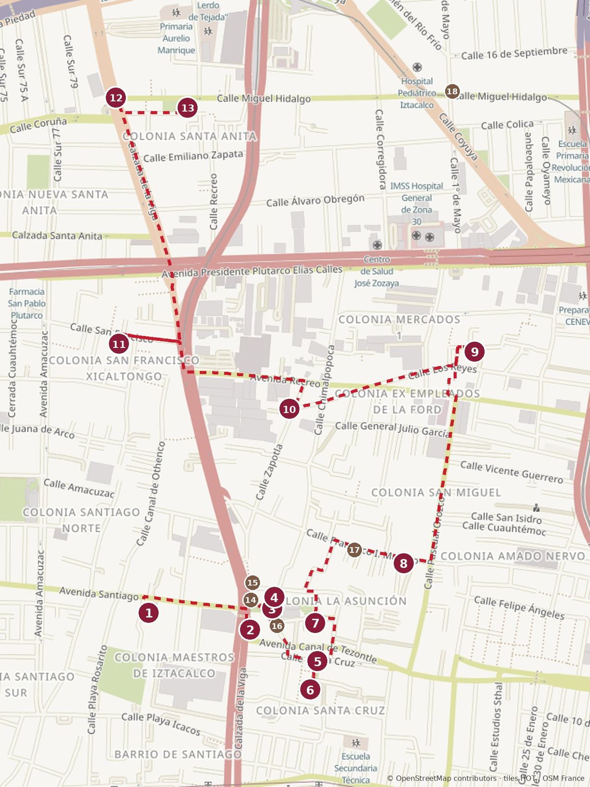
Coffee 14San Matías Café · 15Café Local · 16Bumi · 17Eoz Café · 18Tiempo de Café
Click to enlarge. Map data © OpenStreetMap contributors.
| # | Stop | What it is |
|---|---|---|
| 1 | Santiago Apóstol | Tezontle church |
| 2 | Mercado Iztacalco | Village market |
| 3 | San Matías Apóstol and Plaza Hidalgo | Franciscan church, convent, plaza |
| 4 | Casa de Cultura Siete Barrios | Old jail, now a cultural center |
| 5 | Capilla de la Santa Cruz | Colonial chapel |
| 6 | Ermita de Santa Cruz Atencopa | 17th-century hermitage |
| 7 | Capilla de la Asunción | Twin-towered barrio chapel |
| 8 | Rectoría de San Miguel Arcángel | Barrio de San Miguel church |
| 9 | Parroquia de los Santos Reyes | Barrio de Los Reyes church |
| 10 | San Sebastián Zapotla | Barrio chapel |
| 11 | San Francisco Xicaltongo | 19th-century barrio church |
| 12 | Arco de Santa Anita | Canal boatman monument |
| 13 | Santa Anita Zacatlamanco | Churrigueresque church, finale |
The walk, part 1: Santiago to San Miguel
The first half crosses the old canal to the plaza, then takes in four chapels in less than half a kilometer.
1. Santiago Apóstol
Av. Santiago 54, Santiago Norte · Tue–Sun 8:00–13:30 and 16:00–20:00, closed Mon · free
Start at the church of the Barrio de Santiago, west of the Calzada de la Viga. It has a nearly square tezontle facade between two slim towers and a lot of stained glass inside, with a garden beside it. The feast of Saint James is 25 July.
Weekend breakfast: Barbacoa El Borrego (Playa Cuyutlán, Santiago Sur), about eight minutes west of the church, Sat–Sun 7:00–16:00.
2. Mercado Iztacalco
Canal de Tezontle at Calz. de la Viga · daily 8:00–18:00 · free
Walk about five minutes east and cross the Calzada de la Viga at the lights. On the corner is the village market. It is small and practical: fruit, meat, groceries and a few food counters. The city tourism site recommends its comal quesadillas, sopes and barbacoa, especially at weekends. If you skipped breakfast, eat here. The public toilets are in the market.
3. San Matías Apóstol and Plaza Hidalgo

Cda. Juárez 4 · Mon–Fri 10:00–13:00 and 17:00–19:00, Sat 10:00–13:00; check Sunday · free
Two minutes away is the heart of the island. The Franciscan church and convent were begun in the 16th century and renovated by Rivera Saravia in 1725. Look for the cantera-trimmed facade, the festooned dome, the 18th-century bell tower with its clock and the Greek-cross chapel of the Inmaculada Concepción. The 16th-century baptistery is carved with Franciscan symbols. If the door to the convent is open, ask to see the cloister.
Local legend says San Matías became the patron because a storm stopped a boat carrying his statue here, and the statue grew too heavy to move. The plaza in front has a kiosk, two 19th-century buildings with portales, the island’s glyph (a house with a grain of salt) and a bust of Miguel Hidalgo that Benito Juárez unveiled in 1870. The benches have old photos of the canals.
Coffee break: there are three cafés around the plaza (brown circles on the map). San Matías Café, on the Calzada de la Viga side, does coffee, sandwiches and chilaquiles. Café Local (San Miguel 2) roasts its own coffee, Mon–Fri 10:00–16:00. Bumi (Cda. Juárez 24) is for strawberries and cream and frappés, and Crepería El Capricho in the same building makes giant crêpes on Friday to Sunday evenings.
4. Casa de Cultura Siete Barrios
Cda. Juárez 2A · daily 8:00–21:00 · free
Next to the church is a building that has been a Porfirian jail, the borough’s seat and a party office. Since its restoration in 2003–2006 it has been a cultural center with danzón, painting and yoga classes, and in 2024 it showed INAH’s photographs of the old canal. Look in to see what is on the walls.
Pulque: Los Hombres sin Miedo (Calz. de la Viga 765) is about five minutes north of the plaza, a small pulquería on the line of the old canal. Reviewers call the natural pulque lively and tangy, and there are curados of oats and pecan. If you have never had pulque, share one here. If you have, have two. It opens at 12:00 (Mon 12:00–18:00, Wed–Thu 12:00–20:30, Fri–Sat 12:00–21:00, Sun 12:00–20:00, closed Tue), so on a morning walk it is one to come back for, or walk the route the other way and finish here.
5. Capilla de la Santa Cruz

Amado Nervo at Santa Cruz · daily 7:00–22:00 (Google); check hours · free
Walk about three minutes south-east to the working chapel of the Barrio de Santa Cruz, built between the 17th and 18th centuries, with a Salomonic portal and a main altar in silver leaf dated 1748. It probably began with the Holy Thursday processions that set out from San Matías. Inside are paintings of the Passion. The Fiesta de la Santa Cruz in May is one of the most colorful in the pueblo.
6. Ermita de Santa Cruz Atencopa
Barrio de Santa Cruz, off Amado Nervo · usually closed · free
A minute south is the oldest-looking building on the walk. The hermitage is a 17th-century structure with a dome added about a century later, and it has survived centuries of neglect and other uses. Mass is rare. The city tourism site calls it the usual last stop on walking tours of Santa Cruz, the barrio with the most historic buildings.
7. Capilla de la Asunción
Asunción 22 · rarely open · free
Walk about four minutes north into La Asunción, the most important of the old barrios. Its chapel looks like a small parish church, with a pair of towers on a simple front. Neighbors say it opens on its feast, 15 August, and for the Seven Churches walk on Holy Thursday. Otherwise enjoy the street: La Asunción keeps colonial houses and cobbled lanes.
8. Rectoría de San Miguel Arcángel
Francisco I. Madero 15 · Tue–Sat 9:00–13:00 and 17:00–19:00, Sun Mass times, closed Mon · free
Walk about six minutes north-east. San Miguel has dark stone, two towers and stained glass, with Saint Michael over the main altar. It is also where Iztacalco’s carnival starts each year, when the streets close and the parade sets out from the church.
Coffee break: Eoz Café, a block west of the church, two minutes away (brown circle on the map). Good coffee, breakfasts and a matcha with mango that people come from TikTok for. The owner is friendly. Mon–Fri 8:00–20:00, Sat–Sun 16:00–21:00, so on weekend mornings use the cafés on the plaza instead.
The walk, part 2: Los Reyes to Santa Anita
The second half goes north to Los Reyes, crosses La Viga again and follows the old canal north to Santa Anita.
9. Parroquia de los Santos Reyes
Anáhuac 39, Barrio de los Reyes · check hours · free
Walk about ten minutes north to the church of the barrio of the Three Kings, a small parish with two slim bell towers and a carved wooden altar. Los Reyes is the barrio of the Santo Jubileo in early August, when neighbors pull small decorated floats through the streets.
10. San Sebastián Zapotla
Cerrada Plaza Montemorelos · check hours · free
Walk about seven minutes west. Zapotla’s chapel is small, white and red, with two towers you can see from the narrow street of Los Reyes. Its fiesta for Saint Sebastian falls at the end of January, moved to the nearest weekend, with a torito, a fireworks bull, burned in the street.
11. San Francisco Xicaltongo
San Francisco 36 · Mon–Tue and Thu–Fri 10:00–13:00 and 16:00–18:00, Sat 10:00–13:00; Sunday Mass 8:00, 12:00 and 19:00 · free
Cross the Calzada de la Viga at the lights and walk about eight minutes north-west into the oldest-feeling streets on the walk. Xicaltongo’s lanes are crooked because they follow old footpaths between the chinampas. The 19th-century church has two bell towers meant to recall Assisi and a stone Saint Francis on the facade.
Lunch: La Numancia (Calz. de la Viga 625), a restaurant and bar open daily 7:00–22:00, is about five minutes away, back on the Calzada and on the way north. If you would rather eat at a market, wait for the Mercado Emiliano Zapata at the end (below).
12. Arco de Santa Anita
Av. Hidalgo at Calz. de la Viga · open space · free
Walk about eleven minutes north. At the corner of La Viga is the gate to Santa Anita, put up by the neighbors in 2017, with a canal boatman on top. Canoes once ran from here south to Xochimilco and Lake Chalco, and north into the Centro, some of them selling Santa Anita’s tamales. Stand on the corner and picture water where the traffic is.
13. Santa Anita Zacatlamanco

Av. Hidalgo s/n · Mon–Tue and Thu–Fri 11:00–19:00, Sat 10:00–13:15, Sun 9:00–15:00, closed Wed · free
Three minutes east is the best church on the walk. The present building is mid-18th century; after it fell into poor condition it was renovated in 1777 and given its Churrigueresque facade and altarpiece. The wooden altarpiece is one of the best-preserved of its century in the city, with a 16th-century corn-paste Saint Anne at the center, four Doctors of the Church and reliefs of the Evangelists. The atrium is largely intact. The Viaducto is three blocks north and Metro Santa Anita five minutes away.
Tamales and a market lunch: Santa Anita is still known for tamales; look for stands around Av. Hidalgo, or Tamales Tere (Congreso de la Unión at Av. Hidalgo) for tamales and atole on weekend mornings. Mercado Emiliano Zapata (Emiliano Zapata 55A) is around the corner from the church, with market food, tortas and shrimp empanadas. For coffee after 16:00, Tiempo de Café is about ten minutes east on Av. Hidalgo at 1º de Mayo (brown circle on the map).
Coffee, food and drink
For coffee, go to Eoz Café; for lunch, La Numancia or the Mercado Emiliano Zapata; for a drink, Los Hombres sin Miedo; for tamales, Santa Anita.
| Place | What | Where |
|---|---|---|
| Barbacoa El Borrego | Barbacoa, Sat–Sun 7:00–16:00 | Playa Cuyutlán, Santiago Sur, west of stop 1 |
| Mercado Iztacalco | Quesadillas, sopes, weekend barbacoa | Stop 2 |
| San Matías Café | Coffee, sandwiches, chilaquiles | Calz. de la Viga by the plaza, stop 3 |
| Café Local | Coffee roaster (Mon–Fri 10:00–16:00) | San Miguel 2, by stop 3 |
| Bumi | Strawberries and cream, frappés | Cda. Juárez 24, by stop 3 |
| Crepería El Capricho | Giant crêpes, Fri–Sun evenings | Cda. Juárez 24, by stop 3 |
| Los Hombres sin Miedo | Pulque | Calz. de la Viga 765, north of stop 4 |
| Eoz Café | Coffee, breakfasts, matcha | A block west of stop 8 |
| La Numancia | Restaurant and bar, daily 7:00–22:00 | Calz. de la Viga 625, between stops 11 and 12 |
| Mercado Emiliano Zapata | Market food, tortas, shrimp empanadas | Emiliano Zapata 55A, by stop 13 |
| Tamales Tere | Tamales and atole, weekend mornings | Congreso de la Unión at Av. Hidalgo, near stop 13 |
| Tiempo de Café | Coffee, from 16:00 | Av. Hidalgo at 1º de Mayo, east of stop 13 |
If you just want a familiar cup, there are no chains in the pueblo itself. The nearest are a short ride away:
- Starbucks in the Vía 515 mall, Viaducto Río de la Piedad 515, Granjas México
- Starbucks Portal Centro, Lorenzo Boturini 258, north of the Viaducto
Shops worth the detour
Iztacalco has no shops for visitors, which is part of the point. These are what there is.
- Mercado Iztacalco (stop 2): fruit, vegetables, meat and groceries.
- Café Local (San Miguel 2): coffee roasted on site, weekdays only.
- Mercado Emiliano Zapata (by stop 13): dairy, meat and dried-beef stalls.
- Casa de Cultura Siete Barrios (stop 4): look for workshops and exhibitions on the notice board.
- Mercado de Jamaica: the city’s great flower market, just north of the Viaducto from the finish (see Keep walking).
Which day to walk
Thursday or Friday gets you the most; Wednesday the least. Only the stops and places with limited days are listed below.
| Stop | Mon | Tue–Fri | Sat | Sun |
|---|---|---|---|---|
| 1 Santiago Apóstol | Closed | Open | Open | Open |
| 3 San Matías | Open | Open | Until 13:00 | Check |
| 8 San Miguel Arcángel | Closed | Open | Open | Mass times |
| 11 San Francisco Xicaltongo | Open | Closed Wed | Until 13:00 | Mass only |
| 13 Santa Anita | Open | Closed Wed | Until 13:15 | Until 15:00 |
| Eoz Café | Open | Open | From 16:00 | From 16:00 |
| Los Hombres sin Miedo | Until 18:00 | Closed Tue | Open | Open |
On a weekend, do the walk in reverse, starting at Santa Anita in the morning for tamales and finishing at the plaza, with coffee at San Matías Café and a pulque at Los Hombres sin Miedo.
Keep walking
Iztacalco borders three very different areas.
- North: Mercado de Jamaica. Cross the Viaducto from Santa Anita and walk about ten minutes north to the city’s flower market, open daily, with food stalls of its own.
- East: Ciudad Deportiva Magdalena Mixhuca. The sports city, the Palacio de los Deportes and the Autódromo Hermanos Rodríguez are a short ride east along the Viaducto.
- South: Calzada de la Viga to Mexicaltzingo. Follow the old canal south into Iztapalapa for Barbacoa El Sombrero at Calz. de la Viga 1952 (Tue, Sat and Sun only).
About the author and where to stay
Brian has lived in Roma Norte for about five years and writes the See Mexico City guides. He speaks seven languages and still gets lost on purpose.
When you visit, stay with us at Penthouse El Cielo de Roma in Roma Norte.
Photo credits
Photos via Wikimedia Commons, used under the licenses shown. Numbers match the captions.
- Templo y Antiguo Convento de San Matías Apóstol (Iztacalco) 01.JPG, Dge, CC BY-SA 4.0
- Capilla de la Santa Cruz, Iztacalco 01.jpg, Gunnar Wolf, CC BY-SA 3.0
- Parroquia de Santa Anita Zacatlalmanco Huehuetl 01.jpg, Gunnar Wolf, CC BY-SA 3.0
Map: drawn from OpenStreetMap data, © OpenStreetMap contributors, Open Database License.
Sources
Hours and prices checked October 2026; confirm before you go.
- Wikipedia: Iztacalco
- Mexico City tourism: Plaza e Iglesia de San Matías, Santa Anita Zacatlamanco Huehuetl, Santa Anita Church, Santa Anita Monument and Arch, Hermitage of Santa Cruz Atencopa, Santa Cruz Chapel, San Francisco Xicaltongo, Iztacalco
- Sopitas: Recorrido por Iztacalco, el primer barrio prehispánico de la CDMX
- PUEC-UNAM: San Pedro Iztacalco
- INAH: Boletín 590, 2024 (Iztacalco inédito)
- Crónica: Iztacalco entre alcaldías con mayor avance en baja de percepción de inseguridad, July 2026